![]()
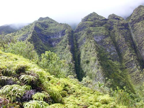
 Photo 1
- Windward face of the pali showing uluhe fern dominating a colluvial deposit in the foreground and strong fluting of the cliff face by intermittent water flows in the background. The top of the cliff is less than half way up the mountain.
Within this sub-basin is the spectacular face the Nu`uanu Pali (cliff), down which flow numerous named and unnamed streams tributary to Kamo`oali`i Stream. These slopes are high (over 2000 feet or 600 m, rising to Pu`u Lanihulu in this sub-basin at 2700 ft or 820 m), steep, and rocky. Near vertical faces are fluted (Photo 1) by the slow erosion of multiple small waterfalls that only develop temporarily during periods of rainfall. Rainfall amounts average greater than 100 inches per year along this part of the Ko`olau crest. At the base of the rocky face occur steep colluvialA deposits supporting dense growths of trees or monotypic stands of uluhe fern (Dicranopteris linearis). While many species of plants occur in the forested areas, trees particularly common here are common guava (Psidium guajava), mango (Mangifera indica), silky oak (Grevillea robusta), Molucca albizia (Paraserianthus falcataria), African tulip (Spathodea campanulata), and kukui (Aleurites moluccana). In places, native pandanus (Pandanus tectorius), `ohi`a (Metrosideros polymorpha) and koa (Acacia koa) are still to be found. The steeper, higher slopes support grasses and shrub growth, regularly watered by cloud drip.
![]()
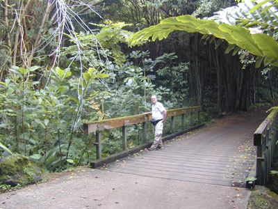
- Photo 2
- Golf cart bridge over Kamo`oali`i Stream at Koolau Golf Course just downstream from TMDL Station 1f.
Perennial flows develop in the streams at elevations between 600 and 800 feet above sea level, from small springs in the rocky colluvium. Flows build rapidly downslope over beds of water rounded stones and boulders. Much of this sub-basin is undeveloped, but below about 500 ft elevation, substantial land area is devoted to two golf courses, the H-3 Freeway right-of-way, banana plantations, windward campus of Hawaii Pacific University (HPU), and Ho`omaluhia Botanical Garden. Portions of four major windward O`ahu highways: Kamehameha, Pali, Likelike, and H-3, occur in this Sub-basin. On the slopes above the north side of Loko Waimaluhia occur residential neighborhoods of Kaneohe town. Thus, while a majority of this sub-basin is "undeveloped," in fact developments occupy substantial portions of the watershed -- it is just that these developments have low densities of roads and structures, as planned in an attempt to preserve the view from the famous Pali Lookout.
Within Ho`omaluhia Botanical Garden, stream riparian zones and slopes near the streams are well vegetated. Slopes around park roads tend to be well-maintained. Elsewhere in this watershed, stream flow may occur in natural beds with dense vegetation (Photo 2; as at Koolau Golf Course), or through lined or unlined ditches (as at the freeway interchange and along Old Pali Road.
Vegetation is as described for the upper parts of Sub-basin 1, with a concentration of banana plants (Musa x paradisiaca) on the slopes above and below the two major highways: Likelike and H-3 freeway. These plants are part of a commercial banana plantation.
TMDL Sta. 2 was located near the bottom of Luluku Stream where it crosses the park road at Ho`omaluhia Botanical Garden. This station represents the discharge from Sub-basin 2. This same location is the site of a USGS gaging station (now inactive) and a USGS NAWQA water quality station.
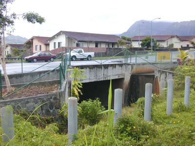
![]()
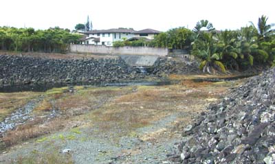
- Photo 3
- Outflow from Ho`omaluhia reservoir (far left; from sub-basin 1) is joined with the flow from Luluku Stream (concrete culvert below house; bottom of sub-basin 2) and continues downslope (far right) as lower Kamo`oali`i Stream in sub-basin 3.
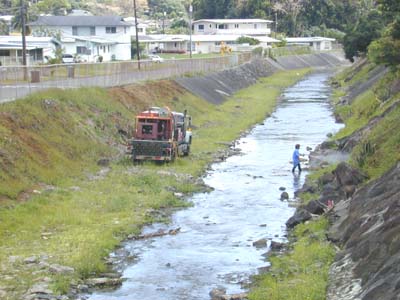
- Photo 4
- Kamo`oali`i Stream is confined between wide, graded and in most places, concrete or concrete-rock masonry (crm), walls. Weedy growth is kept in check by regular herbicide spraying.
This entire reach of Kamo`oali`i Stream receives run-off through numerous street drains as it passes through the Kaneohe neigborhood of Keapuka. Water quality was monitored at TMDL Station 3a located at the lower end of the sub-basin.
![]()
- Photo 5
- Leaving a wetland above Pookela Street, flow is directed into a culvert at the start of the urban land use portion of this sub-watershed.
Water quality was monitored at TMDL Sta. 5 located at the end of Wena Place upstream of the start of the estuary.