|
KANE`OHE STREAM
[continues from Page 1]
Kamo`oali`i Stream
|
|
The longest or upper eastern branch on the Kane`ohe drainage system is apparently unnamed (we suggest Hi`ilaniwai would be fitting). Older USGS maps (prior to 1998) attribute the name Kamo`oali`i Stream to the upper western branch above Ho`omaluhia Reservoir. Both branches arise along the Nu`uanu Pali near the Pali Lookout. The upper reaches of these small streams are intermittent, flowing at and above the cliff face only briefly during periods of heavy rainfall (Photo 5). The largest branch (Hi`ilaniwai) arises in a hanging valley on the north face of one of the the twin peaks of Konahuanui. This peak, rising to 3150 ft (960 m), is the highest point in the Ko`olau. The stream feeds into a narrow gulch (Photo 6) which tumbles under both the old and the new Pali highways. This upper reach of the stream may flow continuously throughout the wet season, drying up in drier summer months.
|
|
|
|
|
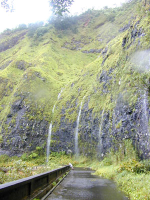
- Photo 5.
 - Numerous small waterfalls flow down the face of the Nu`uanu Pali on days of heavy rainfall. The waterfalls shown here converge flows on and below the old roadway to become Kamo`oali`i Stream flowing behind the Koolau Golf Course clubhouse building.
|
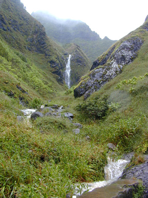
- Photo 6.
- Upper reaches of small streams that become the eastern branch (~ Hi`ilaniwai), here seen from Old Pali Road (now a foot trail). The high waterfall drains one of several hanging valleys that feed into the narrow gulch. This is TMDL Sta. 1g.
|
|
Below Pali Highway, the unnamed (~ Hi`ilaniwai) stream flows under Kionaole Road near the junction with Old Pali Road (area no longer accessible by vehicle) and then northward across the Pali Golf Course to the Kamehameha Highway / H-3 interchange. Another unnamed right branch that is clearly intermittent, arises between the Pali Municipal Golf Course and Castle Junction and flows through the HPU campus, joining Kamo`oali`i underneath the Kamehameha Highway / H-3 interchange. This stream was perennially flowing through HPU, until it was discovered that the source was a leaking pipe at the golf course.
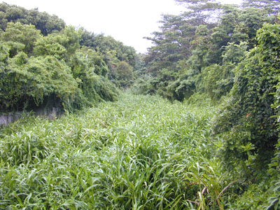

 Photo 7. Photo 7.- Upon exiting from a large culvert beneath the H-3 / Kamehameha Highway interchange, Hi`ilaniwai Stream enters a man-made channel choked with grasses (here mostly elephant grass or Pennisetum purpureum).
Kamo`oali`i Stream and all of its tributaries, except the one passing under the H-3 / Kamehameha Highway exchange, pass under bridges or through culverts along the main access road within Ho`omaluhia Botanical Garden. Included are Luluku, Kuou, Piho, and Ho`oleinaiwa streams.
Many of these small branches are intermittently flowing where they cross under the park road, yet some like Kamo`oali`i are clearly perennial both upstream and downstream of the roadway (see Photo 8).
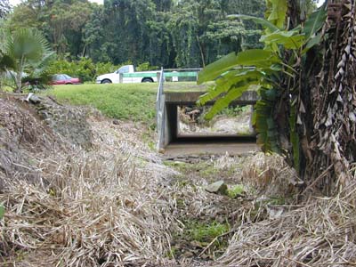
Photo 8.  The furthest bridge inside the park crosses over the stream that arises as small waterfalls near the Pali lookout (Photo 5) which converge and flow through the Koolau Golf Course below the pali. This reach of Kamo`oali`i Stream is intermittent (that is, the stream is interrupted in this area). Looking upstream from TMDL Sta. 1d
Before entering Loko Waimaluhia, Kamo`oali`i Stream flows into a shallow arm of the reservoir over-grown with para grass (Brachiaria mutica) where a wetland of sorts is forming. TMDL Station 1c was located upstream of this wetland.
|
|
Luluku Stream
|
|
Luluku Stream is the first major tributary of Kamo`oali`i Stream upstream of its confluence with Kapunahala Stream. Luluku and its branches drain the slopes of the pali on the south flank of Pu`u Keahiakahoe, flowing through part of the area occupied by the Likelike / H-3 highway interchange (see also Keapuku Stream). The USGS gaging station on Luluku Stream (Photo 8) is presently a NAWQA water quality station. TMDL Sta. 2 was located here.
|
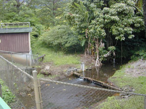
- Photo 9.
-
Luluku Stream was a USGS gaging station (No. 16270900; discontinued after 1998) located beside the Hoomaluhia Botanical Garden access road bridge.
|