Photo 15: Aerial photograph of Kane`ohe by Brian Daniel


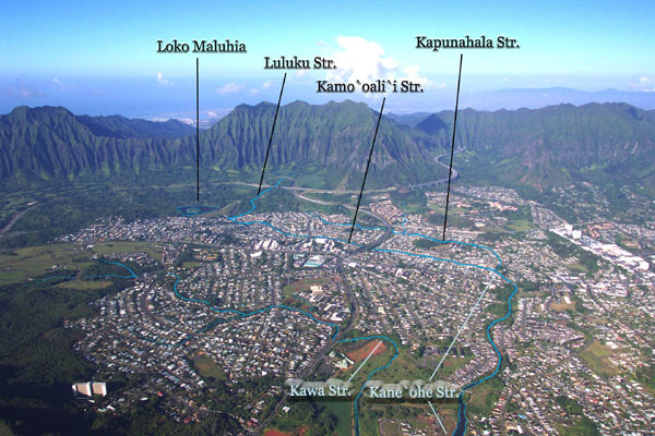
Photo 15. View of Kaneohe Town from on high shows clearly the urban development
that drains to the lower reaches of the Kane`ohe and Kawa watersheds.
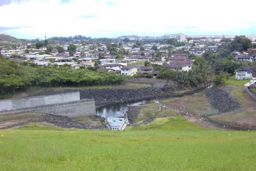
Lower Reach
The earthen and concrete dam that holds back water to form Ho`omaluhia Reservoir (Loko Maluhia) for flood control, also more or less marks the boundary between upstream, undeveloped and open land use (two golf course and major highways) and downstream, urban land use in this watershed. The change from forest to housing can be seen in Photo 16, taken from the top of the dam structure looking north into Kaneohe town. TMDL Station 1a at the base of the dam monitored the influence of the reservoir on Kamo`oali`i Stream water quality.

Photo 16. View north from the top of Hoomaluhia Dam


Photo 16.
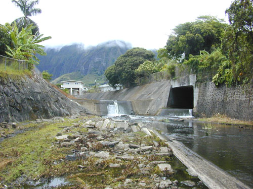
View from the Ho`omaluhia Reservoir dam looking into Kaneohe. Directly below is the reservoir outlet. The overflow spillway structure comes in from the left. The lined channel of lower Luluku Stream can be seen at the boundary of the trees and houses.

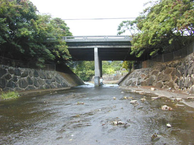
From the dam at Ho`omaluhia, Kamo`oali`i Stream is confined to a modified (lined and straightened) channel. The stream flows north, passing under Likelike Highway (State Rte. 63), then makes a broad turn eastward to pass under Kamehameha Highway (State Rte. 83) on it's way to Kane`ohe Bay (see Photo 15 above). Near the beginning of that broad turn, Kamo`oali`i Stream is joined by Kapunahala Stream (Photo 17) and the combined flows constitute the reach that takes the modern name of Kane`ohe Stream.

Photo 17. Kamo`oali`i and Kapunahala streams flow together to form Kane`ohe Stream


Photo 17.
The confluence of Kamo`oali`i Stream (flowing over the concrete wall in the middle background) and Kapunahala Steam (flowing from the box culvert on the right) marks the start of Kane`ohe Stream (foreground). Photograph shows area near TMDL Sta.s 3a & 4a

Kaneohe Stream has a second NAWQA water quality station (USGS station no. 16274100) in addition to the station on the Luluku branch. This station is located immediately downstream of the concrete culvert structure shown in Photo 18 below. The lined channel ends opposite the soccer park at Kaneohe Civic Center and from here to the mouth, Kane`ohe Stream flows over a natural bed, confined mostly between graded, soil banks.

Photo 18. Looking upstream at the Kamehameha Highway bridge over Kane`ohe Stream
Photo 18.
Kane`ohe Stream beneath Kamehameha Highway (near the Kane`ohe Library) is confined within a massive concrete and crm culvert structure that spreads the flow out into a thin sheet of water.
Photo 19. Looking upstream at Kane`ohe Stream just above the estuary
Photo 19.
Most of the lower reach of Kane`ohe Stream is in a channel that is realigned, but lacks hardened, concrete bed or banks. Photograph taken near TMDL Sta. 5
Photo 20. Looking down the estuary of Kane`ohe Stream from Bay View Golf Course bridge
Photo 20.
The estuary of Kane`ohe Stream is a channel that is dredged from time to time. The Bay View Golf Course, seen here on the right bank, spans the estuary just upstream of the golf cart bridge.
  [PREVIOUS PAGE: Kea`ahala Stream] | [NEXT PAGE: Kawa Stream]    STREAM RING 
  [ ENTRY: Kaneohe Watershed ]  WATERSHED RING 
  [ ENTRY: Kaneohe Bay ]  MARINE RING 

[KO`OLAU NET | AHUPUA`A | RETURN Page 1 | Webmaster]